
Tartaria and the "Star Forts"
Why old maps and old geometry do not match the history we were taught

This essay is part of William J. Teesdale’s Structural Inquiry archive at strategicintentanalysis.com. The method is simple: begin with what is observable, then follow the pattern through recurrence, constraint, and consequence.
No one showed us the shape.
We were shown castles, cathedrals, colonial forts, Roman roads, pyramids, empires, kings, wars, ships, and maps. We were shown fortresses from the ground, if we were shown them at all. The story came with familiar nouns: artillery, defense, borders, engineers, monarchs, colonies, bastions, parade grounds, military science. But the aerial view was mostly withheld.
That is where the story begins to break.
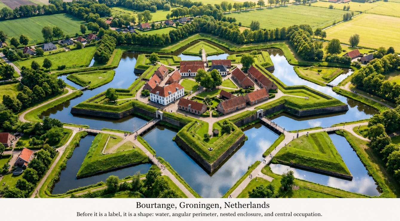
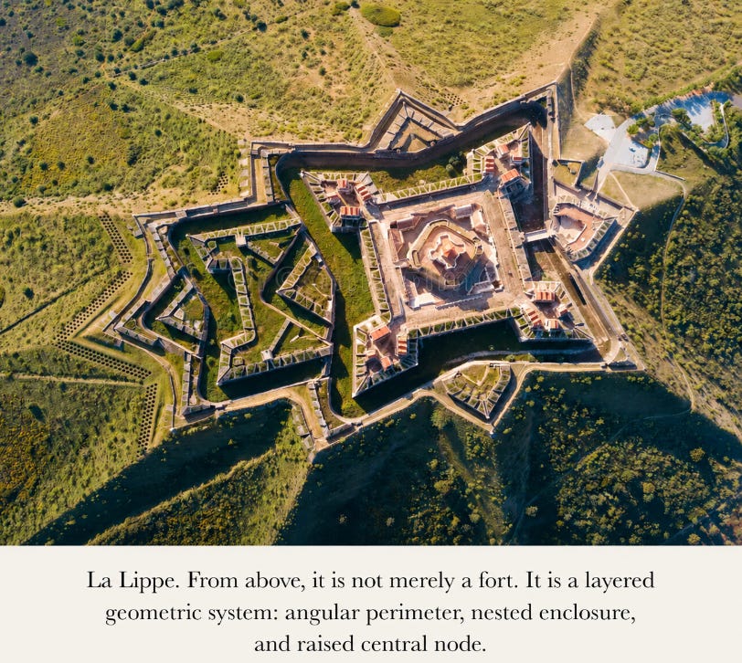
From the ground, “fort” survives. Stone walls, grass slopes, old gates, walkways, cannons, plaques, and masonry make the word feel adequate. From above, the word weakens. The structure becomes something else: a central point, radial order, nested boundaries, repeating projections, water channels, earthwork fields, and often a church, palace, command building, monument, prison, or civic center set inside the geometry as if occupying the heart of the form.
The method here is the method described in The Method of Structural Inquiry: begin with the object, test the explanation against the evidence, and do not confuse institutional description with verdict. A military label is a claim about the structure. It is not the structure itself. The maps, geometry, distribution, reclassifications, omissions, and later symbolic occupations have to be allowed to speak before the label is permitted to close the inquiry.
The modern explanation says these structures are military architecture. That explanation may describe later use. It may describe one layer of occupation, one administrative vocabulary, or one practical adaptation. It does not explain the original form. It does not explain why the same geometry recurs across continents. It does not explain the repeated joining of star geometry to water, earth, central plazas, domes, churches, monuments, command buildings, prisons, and later state symbols. It does not explain why some star cities survive intact, why others appear only in old maps, and why still others are crowned by symbols of a later order.
The failure is categorical. “Fort” reduces geometry to defense. It reduces water to moat, center to parade ground, church to convenience, tower to lookout, brass fitting to hardware, and continent-wide recurrence to military fashion. The explanation begins with the later name attached to the object. It does not begin with the object.
Tartaria presents the same problem in map form.
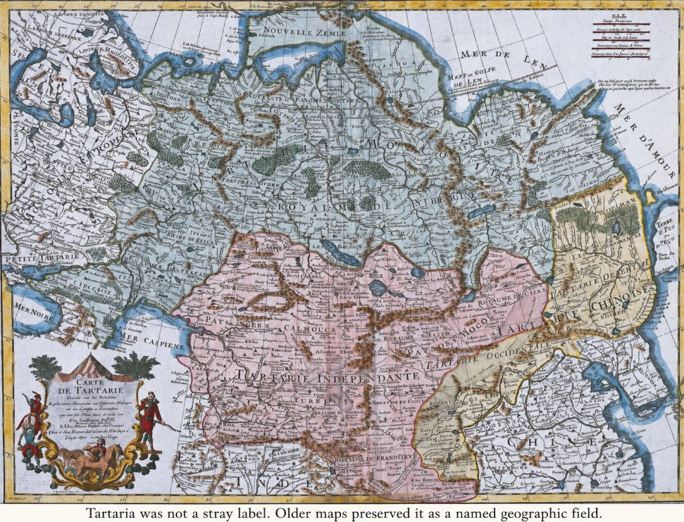
Old maps do not show the world we were taught. They repeatedly show Tartaria, Great Tartary, Chinese Tartary, Asiatic Russia, Anian, Quivira, New India, New France, New Spain, Florida, Norumbega, Saguenay, and other names that have disappeared from ordinary geographic memory. Some names shifted. Some were copied from older sources. Some were distorted by translation or distance. Some may have been applied differently by different mapmakers. None of that makes the names meaningless. A repeated name on the map is a historical fact. A vanished name is also a historical fact.
The standard explanation is that maps improved. Old terms were vague, mistaken, mythical, or obsolete, and the modern map replaced confusion with accuracy. That explanation is too small. It describes the surface of the transition while avoiding the deeper change: an older naming layer was dissolved and replaced by modern administrative categories. Tartaria became Siberia, Asiatic Russia, Central Asia, Mongolia, Manchuria, Chinese frontier, and other fragments. The land remained. The name-field disappeared. Once the name-field disappeared, the possibility of seeing that territory as a coherent historical field disappeared with it.
That is why the minimization of Russia on some star-fort maps is so revealing. Russia had star forts. St. Petersburg alone makes that obvious. But Russia is not merely another country in this inquiry. Russia is the absorption layer over much of the old Tartarian geography. If the star-fort field is shown in Europe, Malta, the Americas, Japan, and India while Russia is visually thinned or omitted, the viewer is prevented from joining the built geometry to the erased map geography. The bridge is removed.
Tartaria should not be reduced to nothing. It should also not be forced into the form of a modern centralized nation-state. The maps suggest something older and less convenient: a civilizational name-field, a political geography, perhaps more unified in some regions and more divided into kingdoms, provinces, alliances, hordes, and successor states in others. Tartaria may have been one thing and many things at the same time. Large civilizational systems often look like that before later states simplify them.
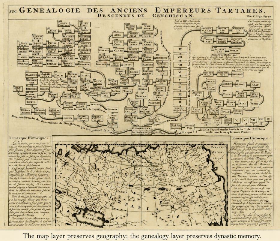
The dynastic material strengthens the point. A genealogy of ancient Tartar emperors descended from Genghis Khan does not read like a label for empty land. It preserves ruler memory, succession, branches, and political continuity. One chart does not settle every branch. It does show that the old record did not treat Tartaria as unknown wilderness. It treated it as a legible political and civilizational field.
America forces the next refinement. If star forts belong to the same old-world built-field, then the large number of star forts in America has to be explained. The crude claim that “star forts equal Tartaria” is inadequate. Tartaria is one major erased name-field. America had its own erased map layer. Old maps preserve Anian Regnum, Quivira Regnum, Cíbola, Teguayo, Norumbega, Saguenay, New Albion, New France, New Spain, Florida, New India, and other names that do not match the simplified continental story we inherited.
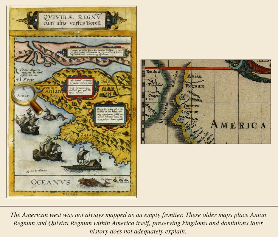
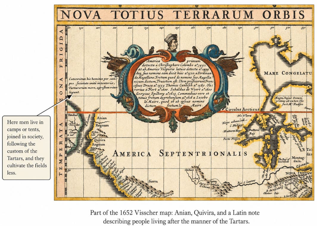
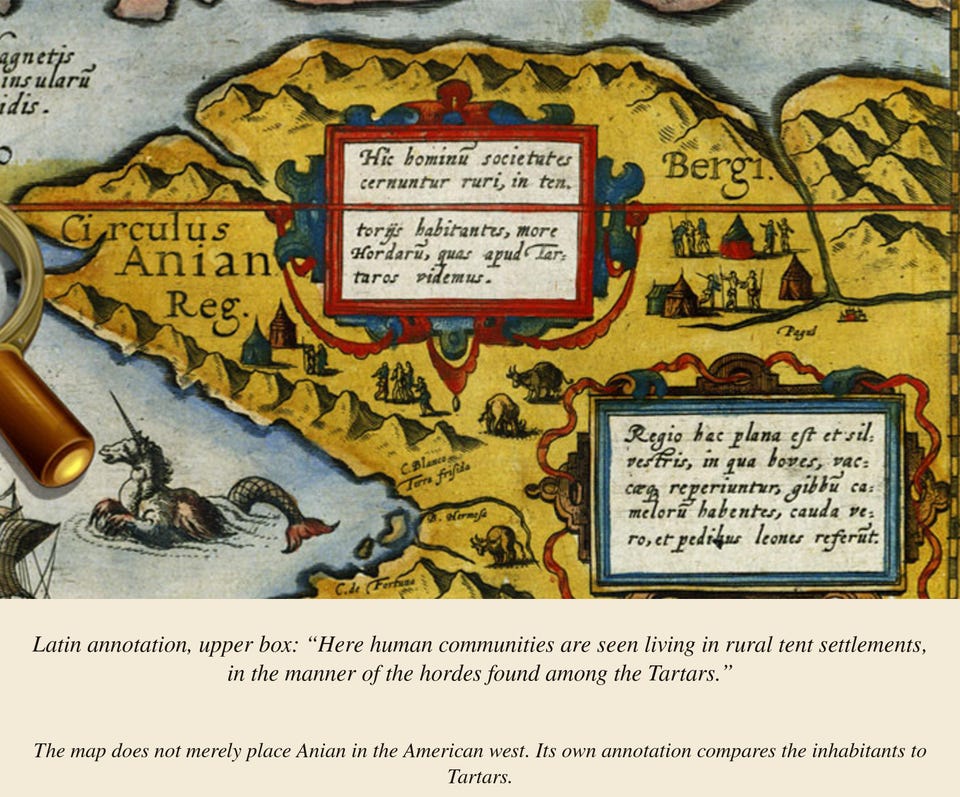
One of the clearest examples is Nicolaes Visscher’s Nova Totius Terrarum Orbis Geographica ac Hydrographica Tabula, published in 1652 and later included in the Atlas Minor sive Totius Orbis Terrarum Contracta Delinea. The map does not merely preserve Anian and Quivira as stray labels. It places Anian Regnum, Quivira Regnum, and the Anian Strait within the American field, while its annotation describes people there as living “after the manner of the Tartars.” That makes the map an important bridge between the American name-field and the Tartarian one.
The word regnum matters. It means kingdom, dominion, or realm. It is not a river label or a mountain label. Anian Regnum and Quivira Regnum preserve a political-geographic claim, or at least a political-geographic memory. The modern story reduces Quivira to Coronado, rumor, failed treasure, Kansas, and disappointment. The old maps place Quivira far to the northwest. They preserve a different geography.
Richard E. Bennett’s “A Nation Now Extinct,” American Indian Origin Theories as of 1820: Samuel L. Mitchill, Martin Harris, and the New York Theory is important here because it shows that the Tartarian connection to North America was not merely a cartographic curiosity. Bennett explains that, by the early nineteenth century, Samuel L. Mitchill of Columbia College had concluded that two major peoples once dominated the Americas: the Tartars of northern Asia and the Australasians of the Polynesian islands. Whatever one makes of Mitchill’s reconstruction, the significance is clear: Tartary was not being treated only as a distant Asian label. It was being used as part of a serious theory of ancient American population, conflict, and replacement.
That matters because the maps and the origin theories preserve the same northern structure. The Anian map places the American passage-zone beside Tartarian language. Bennett’s summary of the older scholarly tradition shows the same pattern in prose: Acosta argued for migration by land or narrow strait; Calancha posited descent from the Tartars of eastern Asia; Brerewood argued for Tartarian origination via Alaska; Humboldt later strengthened the northeast-Asia migration frame. The point is not that one theory settles the history. The point is that the maps, names, annotations, and origin theories all point toward a remembered northern continuity between Tartaria and North America.
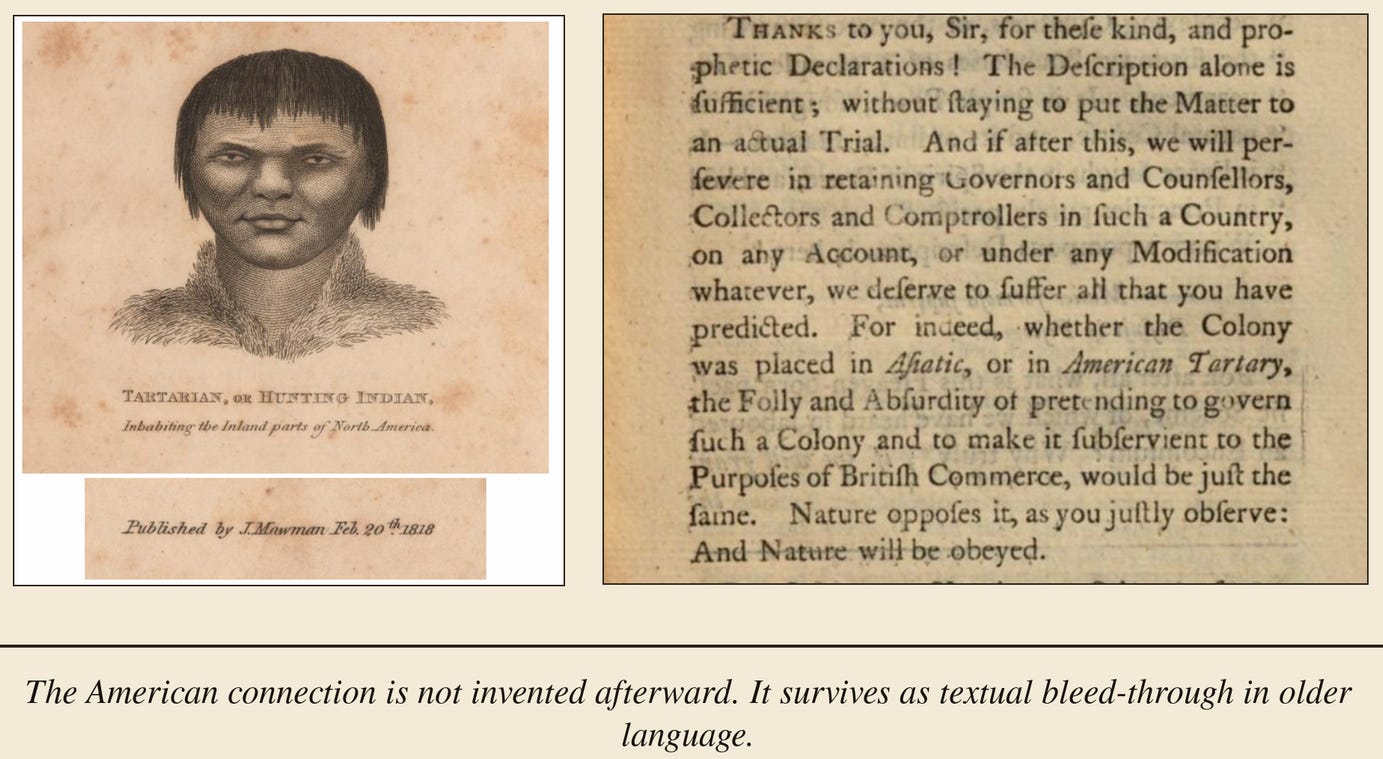
The textual bleed-through is even more disruptive. “American Tartary” appears in eighteenth-century political language as if the phrase could be understood by the reader. An 1818 image captions a figure as “Tartarian, or Hunting Indian, inhabiting the inland parts of North America.” The Quivira tradition also preserves a reported ruler called Tartarrax, a name whose form has been read as suggestive of Tartar Rex, the Tartar King, though the etymology is not established. Their force is narrower and harder to dismiss. They break the clean boundary between Tartaria over there and America over here.
The maps preserve old names. The texts preserve old terms. The star forts preserve old geometry. The later narrative separates the evidence and explains each piece alone: a cartographic error here, a frontier legend there, a failed expedition, a military fort, a colonial outpost, a decorative form, a local engineering style. Fragmentation makes the pattern disappear.
Placed together, the pattern returns.
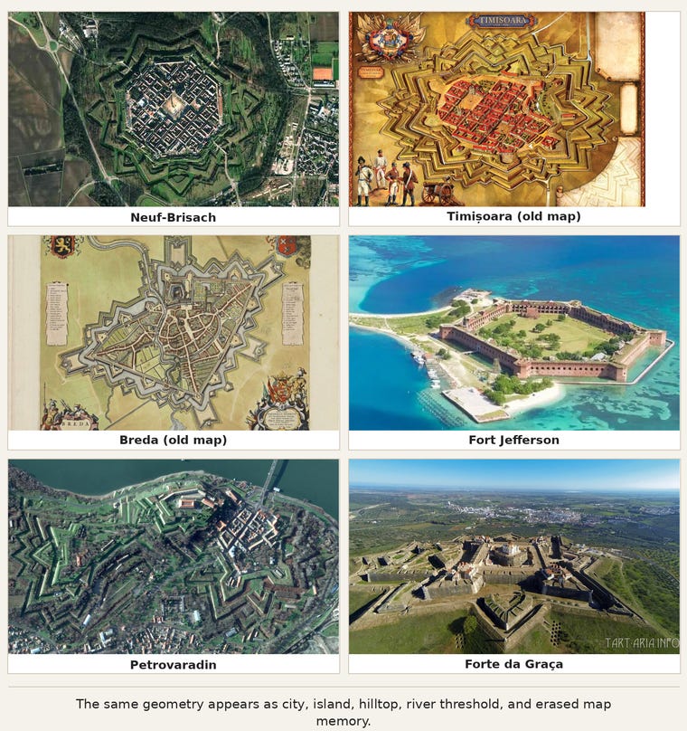
Star forts do not appear as ordinary forts. They appear as a repeated architecture of earth, water, geometry, and centrality. Some are full star cities, like Palmanova. Some are tidal river structures, like Tilbury. Some are island star-water bases, like Fort Wood beneath the monument officially called the Statue of Liberty. Some are American coastal nodes, like Castillo de San Marcos in St. Augustine. Some are erased star-city fields preserved on maps, like Timișoara or Breda. Some are dry elevated hilltop systems, like Forte da Graça. Some are distributed river-threshold fields, like Petrovaradin. Fort Jefferson adds the American island anomaly: a massive remote brick geometry set in shallow turquoise water, officially explained as a coastal defense work despite the absurdity of its scale, isolation, and construction burden.
The variation matters. The form adapts to terrain. Water sites use water. Hilltop sites use elevation, air, horizon, and earth mass. City sites use radial streets and central plazas. Harbor sites use peninsulas, islands, gates, and sea approaches. The medium changes. The grammar remains: boundary, center, repetition, angular projection, enclosure, and field.
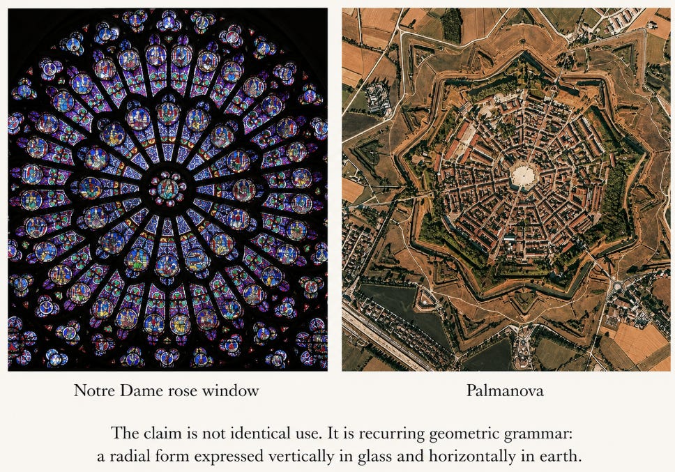
The cathedral system belongs beside this pattern, but carefully. Cathedrals, basilicas, domes, rose windows, vaulted interiors, bell towers, altars, and patterned floors are not identical to star forts. They do, however, share a visible geometric grammar. They organize attention, movement, sound, light, and authority through form. The cathedral uses stone, height, vaulting, bells, procession, light, and central ritual focus. The star fort uses earth, water, perimeter, angular projection, centrality, and landscape placement. One rises. One spreads. Both make geometry operative.
This is where The Pyramid Builders becomes the nearest archive precedent. That essay does not begin with the institutional label and then force the stone to obey it. It begins with the stone. It asks whether the accepted explanation accounts for scale, surface, material, precision, repetition, and technical signature. The same discipline applies here. The first fact is not the label. The first fact is the structure.
A name is not an explanation. Calling a granite box a sarcophagus does not explain how it was made. Calling a massive stone structure a tomb does not explain its material signature. Calling a star geometry a fort does not explain why the same form recurs across water systems, cities, islands, harbors, hilltops, and erased map layers. Later use may be real and documented. It may describe occupation, adaptation, or reclassification. It does not settle origin.
“Fort” misleads in the same way “tomb” can mislead. A later army can occupy a structure. A later cannon can be placed on a wall. A later state can call the site defensive. Reuse is not origin. If an earth-water geometry is later militarized, the military layer may become the public explanation, but it does not exhaust the form. A geometric building can be called religious architecture. That label may describe one layer of use. It does not prove that the deeper function of the geometry was merely symbolic or devotional.
The later powers did not always destroy these structures. Often they marked them.
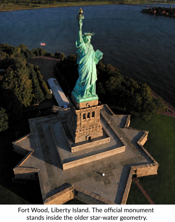
The monument officially called the Statue of Liberty is the clean example. The public name supplies one meaning. The structure supplies another. Beneath the torch-bearing copper figure sits Fort Wood, an eleven-pointed star base on an island in New York Harbor. The arrangement is not neutral: island, water, star geometry, stone pedestal, copper colossus, radiant crown, raised torch. Whatever the official symbolism claims, the structural act is visible. A later figure stands over an older star-water geometry. The base is not erased. It is claimed.
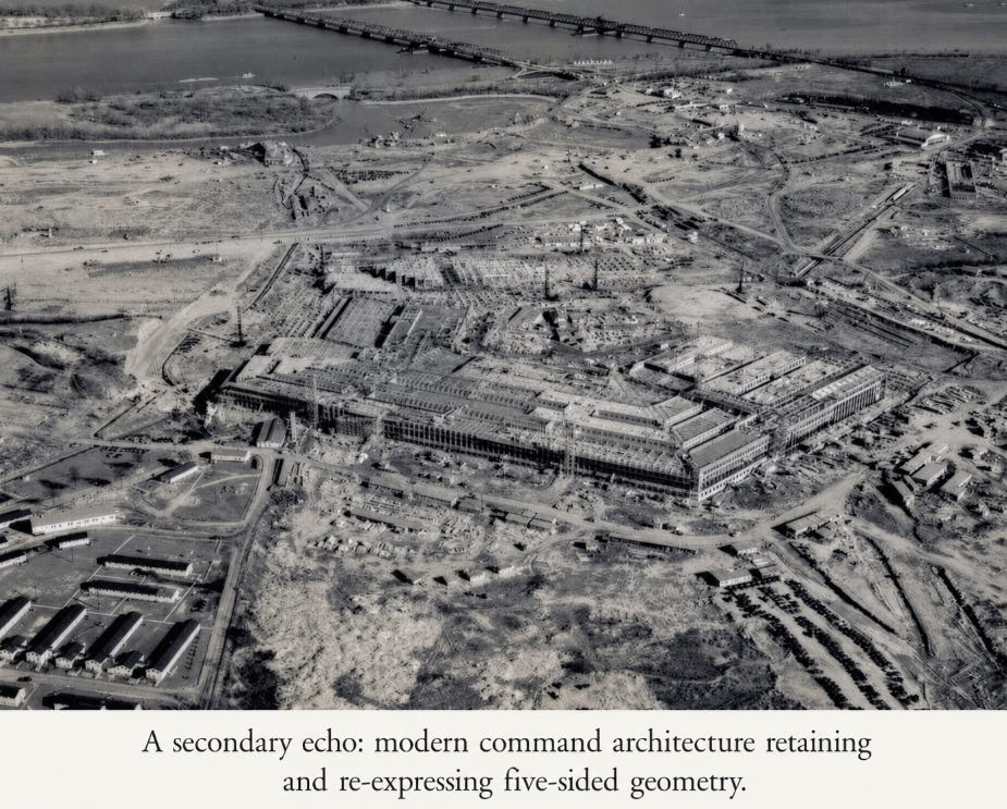
The Pentagon is a secondary echo in command form. It should not carry the weight that Fort Wood carries, but it belongs in the pattern. The official account acknowledges that the five-sided design was retained after the original site condition changed. At minimum, a modern military command structure re-expressed five-sided geometry at imperial scale. The comparison matters less as proof of origin than as evidence that later authority continues to use geometric form when it builds, occupies, and signals command.
These examples reveal conquest more clearly than demolition would. The victor does not always erase the vanquished’s monuments. Sometimes the victor stands on them, renames them, reinterprets them, and teaches the imposed meaning as origin. The old structure remains visible but becomes unintelligible. The population learns the overlay and forgets the base.
That is the larger pattern.
Tartaria was removed from the map by replacement. Star forts were removed from memory by reclassification. Cathedrals were narrowed into religious architecture. Rose windows became decoration. Water systems became moats. Central plazas became parade grounds. Brass plates in corner towers became drains. Star cities became military planning. Old American kingdoms became myths, errors, or legends. American Tartary became a phrase no one remembers. The structures remained. The key was removed.
Permission to Observe belongs here because the issue is not only evidence. It is permission. Star forts were never truly invisible. The maps were not all burned. The cities were not all buried. The geometry remained available. The objects were named before they were seen. Once the public received the category, perception was governed by the category. People did not fail to see because nothing was visible. They failed to see because the permitted meaning had already arrived.
That is the educational omission. If children had been shown the aerial images, the questions would have appeared immediately. Why are there so many? Why are they so precise? Why do they repeat across continents? Why do they resemble rose windows and sacred geometry? Why are central churches, plazas, monuments, palaces, prisons, and command buildings placed inside them? Why are so many connected to water? Why are some erased but still visible on old maps? Why do old maps show Tartaria and American kingdoms that modern history treats as marginal or unreal?
The story has no answer for those questions because the story depends on fragmentation.
One site is a fort. One map is an error. One kingdom is a legend. One old name is a curiosity. One star base under a monument is a coincidence. One pentagonal command building is a practical design choice. One erased city is urban development. One cathedral is religion. One rose window is ornament. One Russian omission is catalogue bias.
The shared mechanism is replacement. The map layer was dissolved by renaming old geographic fields into modern administrative units. The built layer was dissolved by renaming old geometric structures as forts, churches, civic plans, monuments, or military sites. The same operation separated name from structure, structure from function, and function from memory.
Together, they form a system.
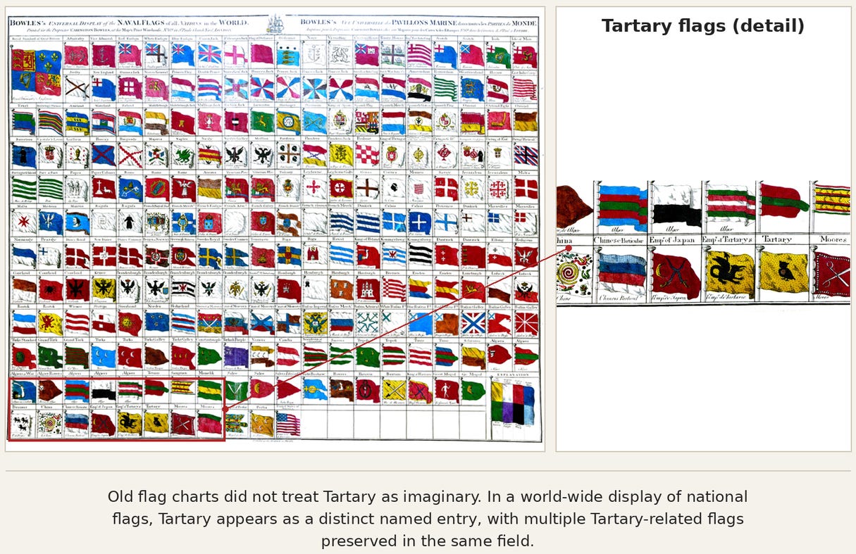
The flag chart adds a final documentary layer. Tartaria was not preserved only as geography on old maps. It also appeared in older national flag systems, where it was treated as a recognized political name with its own symbols. Older documentary systems did not treat Tartaria as imaginary. They gave it flags.
The conclusion follows from the evidence, not from the official statements made about the evidence. Those statements are part of the record. They are not the measure of the record. The measure is correspondence: whether the explanation accounts for the maps, the forms, the distribution, the reclassification, the omissions, and the visible placement of later authority over older nodes.
It does not.
The old maps remember a world the modern map erased. The old geometry preserves a system the modern story reduced to military architecture. Tartaria and the star forts are not separate anomalies. They are two surviving witnesses to the same overwritten world.
Tartaria was not erased because it was nothing. It was erased because it named too much. The star forts were not hidden because every wall was buried. They were hidden because the surviving geometry was given the wrong name.