
Tartaria Beyond the Maps
Why a documented world was reduced to myth and error

The maps are the visible surface. The travel accounts show what the maps were naming.
Tartaria was not erased as a country first. It was erased as a way of recognizing civilization.
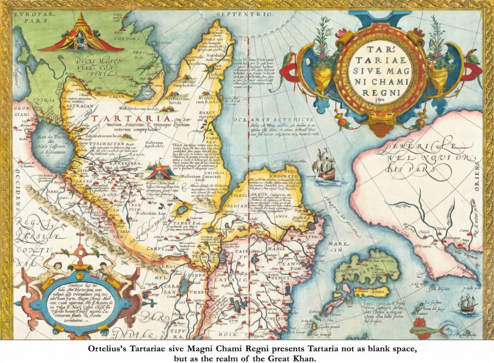
That distinction matters. If Tartaria is forced into the shape of a modern state, the inquiry fails before it begins. Modern states have fixed borders, permanent capitals, bureaucratic archives, standing departments, and administrative maps. Tartaria appears in the older record as something larger and harder to classify: a civilizational field, sometimes imperial, sometimes divided, sometimes mobile, sometimes court-centered, sometimes successor-ruled, but never empty.
The error is not that old maps remembered Tartaria. The error is that modern categories taught us to stop understanding what those maps preserved.
The method is the one developed in The Method of Structural Inquiry: begin with what is observable, then test the explanation against the full structure of the evidence. A label is not a verdict. “Nomad,” “steppe,” “tribe,” “frontier,” “Mongol,” “Tatar,” “Central Asia,” “Siberia,” and “cartographic convention” may each describe part of the record. None explains the whole.
The older sources describe a world.
John of Plano Carpini and Benedict the Pole describe a papal mission into Tartar authority in the thirteenth century. The envoys did not wander through vague territory. They moved through controlled space, were escorted between camps, brought gifts, submitted to fire purification, encountered Batu, and were sent onward toward Kuyuk Khan. This is political order: hierarchy, access, protocol, danger, and imperial command.
William of Rubruck gives the world its texture. He describes a people whose order moved with them. Captains knew the limits of pasture lands. Winter and summer movement followed season, temperature, grass, and water. Snow itself could serve as water. Their dwellings were circular felt structures set on frames. Their wealth was portable but not primitive: horses, carts, textiles, skins, metalwork, furs, milk, meat, roads, rank, and court ceremony.
Rubruck’s description of Batu’s ordu is decisive. He says it appeared like a great city spread around the ruler’s dwelling. The court sat in the middle. People knew where they belonged around it. That is the part modern history often misses. The center moved, but the order remained.
This was mobility without rootlessness.
Rubruck describes women driving carts, loading camels, making clothing, boots, and leather goods, riding skillfully, and sometimes shooting bows like men. He describes coordinated hunts in which whole districts were surrounded until game was enclosed. He describes rich clothing lined with silk stuffing, soft, light, and warm. He describes food customs, horseflesh, mare’s milk, hides cured into jars, shoes made from horsehide, and meat divided with precision among guests.
None of this is absence. It is a complete operating life.
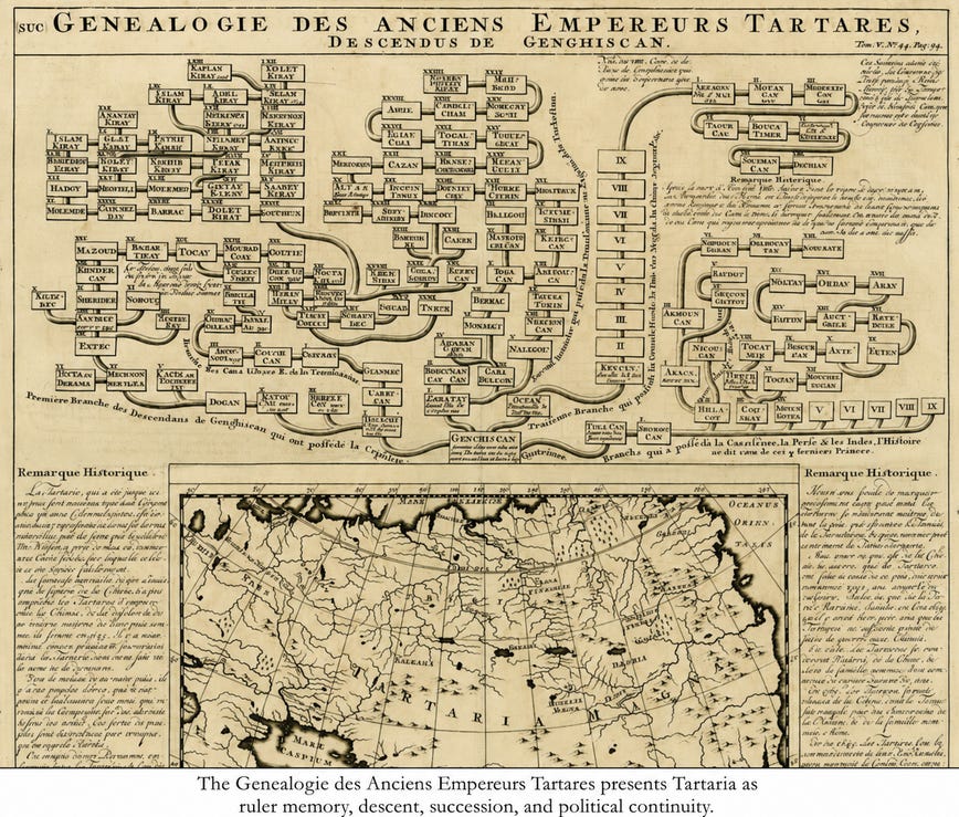
The genealogical material belongs here because it prevents the easy reduction of Tartaria into empty geography. A genealogy of Tartar emperors descended from Genghis Khan is not a label for wilderness. It preserves ruler memory, descent, succession, and political continuity. One chart does not settle every boundary or dynasty, but it does show how the older record thought: Tartary was legible as rule, not merely land.
This is also why the essay must not concede the modern frame too quickly. The modern label “Mongol Empire” describes one historical layer. The older European map-field places that imperial world inside the broader Tartarian frame. The point is not to deny the modern label. The point is to see the civilizational form the older record preserves.
That form becomes unforgettable in Rubruck’s description of the Silver Tree at Karakorum. At the court of the Great Khan, a Parisian craftsman made a mechanical drinking fountain in the form of a great silver tree. At its roots stood silver lions. Through hidden conduits flowed mare’s milk, wine, honey drink, and rice mead. Gilded serpents wound through the branches. An angel with a trumpet stood above. A hidden operator made the angel sound, and servants released the drinks through the system into waiting bowls.
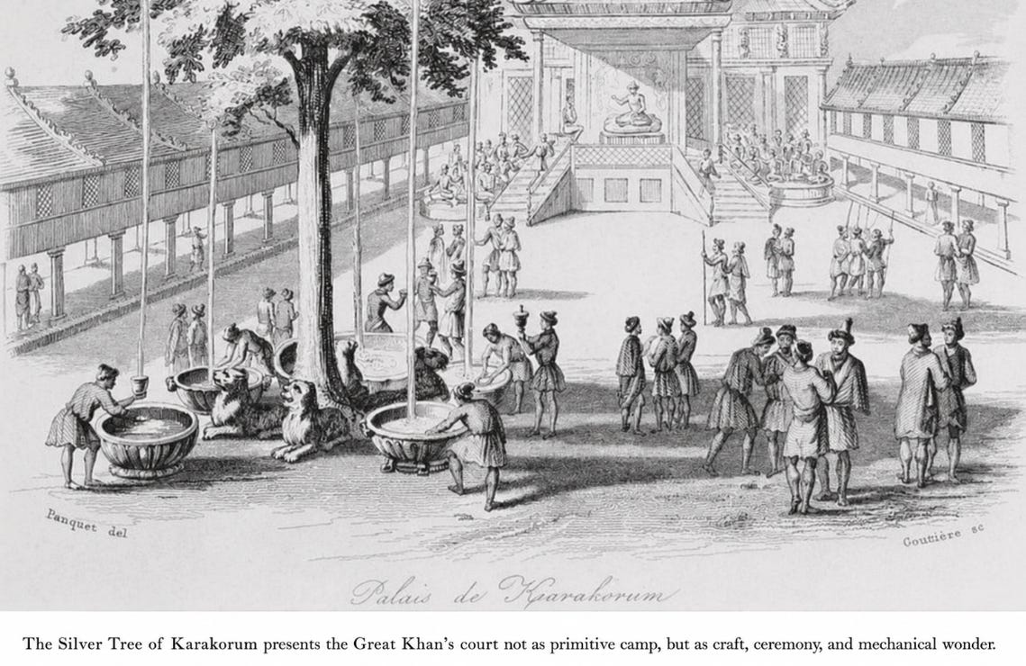
That single image breaks the permitted category. A mobile civilization is not therefore a primitive civilization. A court that can receive envoys, command roads, employ foreign craftsmen, stage mechanical wonder, and arrange ceremony through metal, sound, drink, and hierarchy cannot be dismissed by calling it nomadic.
The burial evidence deepens the point. Rubruck describes tumuli, statues facing east holding cups, pyramidal structures for the rich, tiled towers, stone houses where no stones were local, horse skins hung toward the four quarters, and food and drink placed for the dead. This is rank, memory, direction, and sacred geography.
Here The Sky as Clock becomes relevant. Older civilizations did not meet the sky as empty background. They read recurrence, direction, eclipse, lunar rhythm, seasonal return, balance, and timing as order. Rubruck records diviners who predicted eclipses of the sun and moon. They judged lucky and unlucky days. Armies were not assembled without their assent. Time was not merely counted. It was located.
This is one reason Tartaria became difficult for later categories to preserve. Its religious life was not easily separable from its political life, and its political life was not easily separable from land, season, direction, and sky. Fire purification guarded access to authority. Diviners helped determine the timing of armies and war. Burial figures faced east. Offerings were made toward the four quarters. To modern institutions, these become separate subjects: religion, astronomy, military history, folklore, archaeology, and ethnography. In the older order, they were not separate. They formed one lawful field.
This does not require forcing a complete astral religion onto the evidence. It requires only that the evidence be allowed to speak. Fire purification, east-facing burial statues, the four quarters, eclipse prediction, seasonal migration, and divinatory timing all belong to a world in which sky, land, movement, and authority remained joined.
Pegolotti supplies the commercial proof. His merchant instructions for the route from Tana toward Cathay are not mythic. They are practical: roads, safety, tolls, officers, lords, silver, exchange, risk, paper money, and rules if a merchant died. A trade route can only be described this way if recognized authority exists along it. Commerce does not move across a void. It moves through negotiated order.
Marco Polo should not carry the whole argument, but he belongs inside the cumulative field. In the western part of the route, his account places the Polo family at the court of Berke Khan, with Sarai and Bolgar as named centers of power. Farther east, he describes Kublai Khan’s court, imperial seating, barons, relatives of the imperial blood, court feasts, foreign visitors, gift-giving, and Tartar religious customs. Polo matters because he fits the wider pattern already established by Carpini, Benedict, Rubruck, and Pegolotti.
Clavijo and Schiltberger extend the pattern. Clavijo’s embassy to Timour at Samarkand records diplomatic movement into a Central Asian imperial court. Schiltberger preserves Great Tatary, White Tatary, Kiptchak, Sarai, khans, and steppe divisions. The form changes. The field remains.
This is the same mechanism examined in Tartaria and the Star Forts. The old name-field is dissolved and replaced by later administrative categories. Tartaria becomes Siberia, Asiatic Russia, Central Asia, Mongolia, Manchuria, Chinese frontier, Islamic khanate, ethnographic residue, or map error. The land remains. The name-field disappears. Once the name-field disappears, the ability to see the civilizational field disappears with it.
The concealment need not have occurred through one central act of deletion. It could occur through category replacement. Tartaria did not have to be burned out of the record if it could be divided into safer modern terms: Siberia, Central Asia, Mongolia, Manchuria, Russian frontier, Chinese frontier, Islamic khanates, steppe peoples, and nomadic ethnography. Each category preserved a fragment. None preserved the field. The effect, whether intentional or not, was the same: a mobile civilizational order became difficult to see.
“Nomad” performs the same operation. It becomes a dismissal rather than a description. Portable dwellings become lack of architecture. Seasonal territory becomes wandering. Moving court becomes absence of capital. Oral command becomes absence of law. Fire ritual becomes superstition. Celestial timing becomes primitive astrology. Women’s competence becomes curiosity. Burial monuments become ethnography. Mechanical court ceremony becomes an isolated marvel.
Placed together, the fragments say something else.
They describe mobility with structure. Wealth without industrial settlement. Hierarchy without modern bureaucracy. Sacred order not easily contained by later institutional religious categories. Courtly magnificence without the fixed capital model. A civilization of routes, horses, seasons, metals, textiles, envoys, rivers, sky, fire, memory, and command.
That is why the erasure matters. Tartaria challenges not merely a map. It challenges a definition of civilization.
The modern world teaches that civilization is fixed settlement, masonry permanence, bureaucratic record, centralized state power, and institutional religion. Tartaria preserves another possibility: civilization can move. It can organize around court, route, pasture, tribute, season, and sky. It can carry its center without losing order. It can build memory through genealogy, ritual, road, and recurring movement rather than through the modern archive alone.
This does not require Tartaria to have been one uninterrupted centralized state. The evidence does not need that claim. It shows something more difficult for modern history to absorb: a broad civilizational field whose forms changed without becoming unreal.
The sources were not all destroyed. They were separated.
One map became an old error.
One traveler became a medieval curiosity.
One road became trade history.
One court became Mongol history.
One genealogy became dynastic antiquarianism.
One burial practice became ethnography.
One sky practice became superstition.
One mobile civilization became “nomads.”
Placed together, the field returns.
Tartaria was hidden less by the destruction of evidence than by the loss of the category needed to read the evidence. What disappeared was not only a name, but a way of seeing a civilization that did not organize itself according to the modern state.
The maps remembered the name.
The travelers remembered the world.
The lost lesson of Tartaria is that civilization can move.